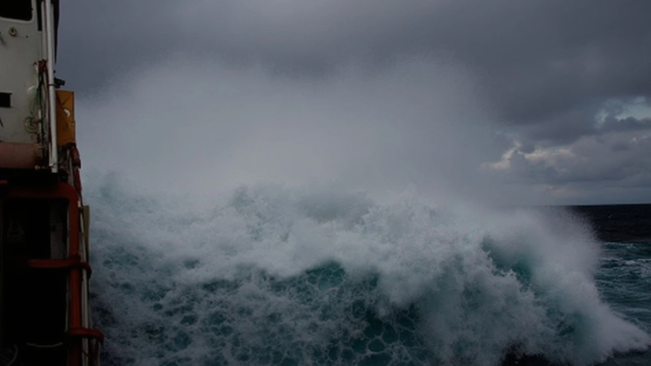
Heads up if you're heading near the water in the Western Cape or Namaqua coastline this week—the South African Weather Service has issued a damaging waves warning from July 16 to 18, 2025. The weather system coming through isn’t your average squall: we’re talking waves between 4.5 and 6 meters tall. That’s about the height of a two-story building. All this is thanks to a cold front moving in, stirring up the Southwest coast starting Thursday afternoon and stretching all the way to Alexander Bay by Friday.
The areas in the spotlight include the well-known stretch from Plettenberg Bay to Saldanha Bay. By Friday, the rough seas are expected to extend right up to Alexander Bay, blanketing a huge part of the coastline in unpredictable, hefty surf. Local surfers might be itching to check out the action, but this is no time to be casual about the sea.
The blustery south-westerly winds, clocking in at 40 to 60 km/h, are more than just a nuisance. When those winds start cranking up, they whip the waves even higher, making beach visits and harbour activities especially dangerous. If you’ve ever seen news reports of people getting swept off rocks or boats struggling just offshore, that’s exactly the risk officials are worried about for the next few days.
Here are the main dangers officials say to watch out for:
Municipal officials and emergency services have jumped into action, urging everyone to steer clear of the water and avoid taking risks near the shore. Regulars on the coastal hiking trails should also be alert—one misjudged wave could be all it takes for a dangerous situation to turn deadly.
The warning for damaging waves comes at a time when this coastline is already on edge: winter usually brings heavier storms, but systems of this size can add an extra element of danger for residents, fishermen, and travelers passing through. If you're planning to be in the affected regions—or know someone who is—it’s smart to check for real-time weather updates before heading out, and prioritize safety over adventure. Local authorities stress: this is not the week to challenge the ocean's power.
July 17, 2025 AT 19:00
Yo folks!!! The wave alert is no joke-those 4.5‑6 m walls can smash anything in minutes!!! If you’re near Plettenberg Bay or Saldanha, steer clear of the rocks, avoid kayaking, and definitely don’t try to surf-just stay inland!! Stay safe and spread the word!!
July 17, 2025 AT 19:33
Whoa… the ocean’s about to unleash a monster! 🌊⚡️ Imagine a two‑story building rolling in on a wave-talk about drama!!! If you’re planning any beach day, think twice, pack a warm coat, and maybe binge‑watch a series instead of risking a splash!!!
July 17, 2025 AT 20:06
According to the meteorological data released by the South African Weather Service, the impending cold front is forecasted to generate wind speeds ranging between 40 and 60 km/h, which in turn will significantly amplify the wave heights along the Western Cape shoreline. Such wind velocities are sufficient to induce rapid upwelling, thereby increasing the kinetic energy transferred to the ocean surface. Consequently, wave amplitudes of 4.5 to 6 meters are expected to persist throughout the warning period from July 16 to July 18, 2025. The physical impact of waves of this magnitude on coastal infrastructure can be severe, as they are capable of exerting pressures exceeding several kilopascals upon impact. Coastal communities, particularly those situated between Plettenberg Bay and Saldanha Bay, should therefore anticipate heightened risk of coastal erosion and structural strain on harbour facilities. Small craft, including fishing vessels and recreational kayaks, are especially vulnerable to capsizing under such conditions due to the combination of high wave steepness and abrupt current reversals. It is advisable for mariners to seek sheltered anchorages well inland of the open sea and to monitor real‑time tide and wave forecasts via official channels. Moreover, lifeguard services are likely to enforce temporary closures of popular swimming zones to mitigate the danger of accidental submersion. Residents engaging in coastal hiking should remain vigilant for sudden wave run‑ups that may inundate adjacent pathways. The warning also underscores the potential for interruptions to maritime logistics, as port operations from Plettenberg Bay to Alexander Bay may be delayed or temporarily halted for safety reasons. Authorities have recommended that individuals refrain from any unnecessary exposure to the shoreline until the advisory period concludes. In summary, the confluence of strong south‑westerly winds and a potent cold front creates a hazardous marine environment, and prudent avoidance of the water is the most effective mitigation strategy.
July 17, 2025 AT 20:40
Adding to Ranveer’s point, the safest route during this warning is to stay well back from the immediate shoreline-especially near the rocky outcrops where waves can surge with little warning. If you’re a fisherfolk, consider moving to more protected bays or awaiting the calm after the front passes. Your vessel’s stability improves dramatically when you avoid the exposed stretch between Plettenberg and Saldanha. Let’s all prioritize caution and ensure the community stays intact.
July 17, 2025 AT 21:13
Building on Tejas’s dramatic description, it’s worth noting that the sea‑state forecasts also predict a significant swell period, which means the waves will have more energy and will travel farther inland than usual. If you’re planning a hike along the coastal trails, watch for sudden water level rises on the path, and be ready to turn back. Staying informed via local weather alerts can prevent a nasty surprise.
July 17, 2025 AT 21:46
Totally agree with Santosh-stay away from the rocks! I tf llke ths tme, wlth all the wavez you lookin to kke.
July 17, 2025 AT 22:20
Seriously? Another warning? People need to learn to listen to common sense instead of constantly bragging about "braving" the ocean. This nonsense is just another excuse for reckless idiots to end up as a headline.
July 17, 2025 AT 22:53
Wave dynamics here intersect with coastal morphodynamics, producing heightened shear stress on littoral zones. Practitioners should adopt a risk‑aware stance.
July 17, 2025 AT 23:26
Sounds like a lot of drama 🙄
July 18, 2025 AT 00:00
Stay safe out there! 🌞 The ocean’s mighty, but we’re smarter. Keep an eye on the alerts and enjoy the sunny side of life.
July 18, 2025 AT 00:33
Reflecting on the collective insights shared thus far, it becomes evident that the intersection of meteorological forecasts and cultural practices along the Western Cape coastline necessitates a holistic approach to safety. While the raw data convey the physical magnitude of the impending swell, the societal response-shaped by local traditions, maritime heritage, and community resilience-plays an equally pivotal role in mitigating risk. Consequently, it is advisable for stakeholders, ranging from municipal authorities to individual beachgoers, to engage in proactive dialogue, disseminating clear, jargon‑light advisories while respecting the lived experiences of coastal residents. By fostering an inclusive narrative that balances scientific precision with empathetic outreach, we can transform a potentially hazardous episode into an opportunity for communal solidarity and heightened environmental awareness.